Categories
Fire Safe News Fire-Wise Landscaping

Thoughts on the Los Angeles 2025 Fires by Greg Rubin

Greg Rubin is a landscape contractor specializing in California native plants. He is the founder of California’s Own Native Landscape Design, Inc. and has designed and installed over 700 native landscapes in Southern California.

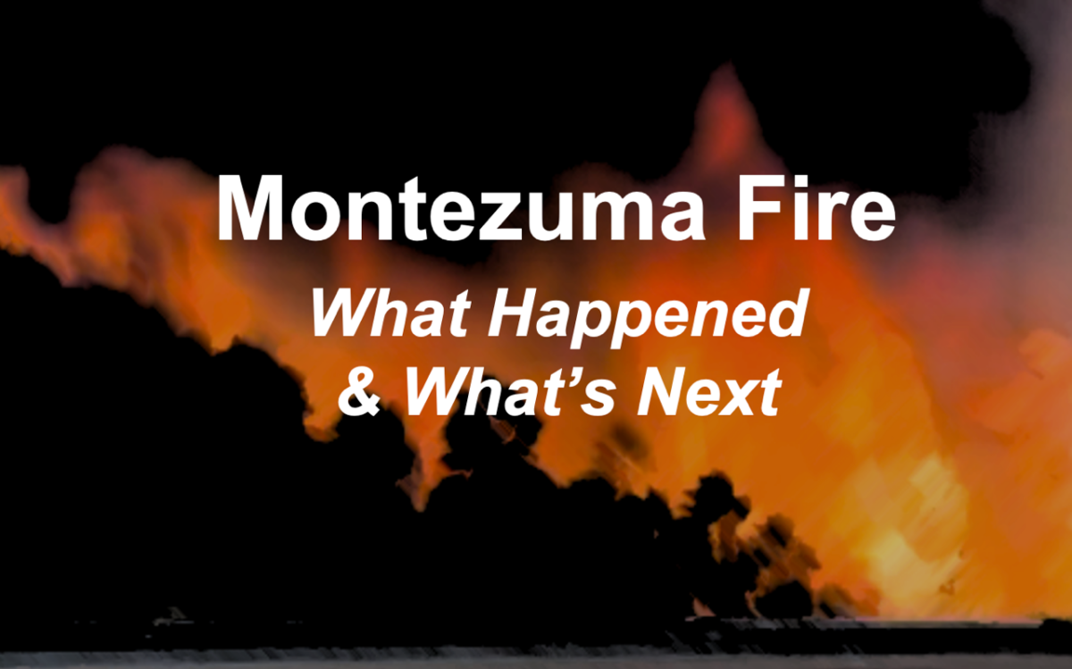
After witnessing the horror in LA earlier this month, I just want to start by sharing my condolences with anyone who was affected by this nightmare, including those who lost their homes, pets, or God forbid, friends and family. It truly was the “perfect (fire)storm”, and I wanted to share some thoughts about ways we can better prepare ourselves for the next one, which at this point seems inevitable. I have some experience in this area, going back to around 1998, when some of my first clients were hit by wildfire. Since then, we’ve had about 20 or so homes that have experienced major fire events (such as Poomacha, Pines, Cedar, Witch Creek, Harris, etc.) and we have yet to lose a home (thanking our lucky stars). While I could never guarantee a home won’t burn in a firestorm, especially as violent as these, there are quite a few things we can do that will give us a much better chance of success and create defensibility without destroying the natural environment that we so love. I will apologize in advance for the length of this article.

My primary mentor along the way was the late Bert Wilson, owner of Las Pilitas native nursery, who was also a CalFire firefighter for 14 years. He had stressed the importance of fire safety since the beginning, some 30 years ago, and how so much of the conventional wisdom about chaparral (not forest!) fire ecology is misguided, and that much of what we have been told can make the problem worse. Using his protocols along the Wildland-Urban Interface (WUI) has led to dramatic, positive results. The response of the native landscapes to fire has played out pretty much as predicted.

Here is a summary of basic assumptions that feed into what has been a successful approach, later tested in a 4-year research study for the US Navy, with Dr. Jon Keeley and me as the Co-Principal Investigators:

• Hydration, not plant selection, generally determines flammability (in most cases).

• It requires very little supplemental water to hydrate drought-tolerant native plants, on the level of a summer thunderstorm or fog drip 2-3 times per month during the warm season.

• Using light overhead irrigation, like MP-Rotators, is essential to watering the whole symbiotic mycorrhizal biome, and is key to matting down the shredded mulch, leaving it as a dense, low, poorly oxygenated fuel that burns (smolders?) with low flame height. Shredded mulch adheres to the soil in this process. It also enhances the ability of the plants to maintain hydration levels by promoting moisture retention in the soil and the mycorrhizal fungi.

• Lightly hydrated native vegetation can catch and cool embers, while providing obstacles to disturb the ferocious flow of wind-blown ignition sources before they hit your house, fire then spreading from house to house.

• Many of the plants characterized as the worst “fire-bombs” benefit the most from light hydration.

• While most of our clients had enough property to implement these defensible landscape principles individually, they can be applied at the community level as well.

• The zonal approach can be very helpful, especially Zone 0 (0-5’ from the house) and Zone 1 (subsequent 30-50’ or more).

• True fire resistance starts at the house outward, not the landscape inward.

The sad truth in both the Palisades and Eaton fires is that these communities were comprised of closely packed homes, most of which were constructed before fire-resistant architecture was the norm. These developments were wide open to wind-driven ember attack, virtually independent of home landscapes – so many of the trees still stood green after the devastation. The preceding 8 months of extreme drought certainly didn’t help the situation.

The finger pointing is in full force, blaming politicians, agencies, and conservationists. Much of the response has been to turn the native plant communities into a boogeyman, reduced in description to “brush” or “fuel”. Many would have us strip the hillsides if they could. Certainly many insurance companies agree with this. This is one of the problems with categorizing these burns as fuel-driven, instead of wind-driven. Removing the native shrublands only replaces one “fuel” with another – flashy non-native weeds and grasses. Erosion would be out of control, habitat would be eradicated, and the whole area would be well on its way to desertification. Many areas of Riverside County are a good example, unfortunately.

So how do we protect an entire community? For starters, create lightly irrigated greenbelts as buffers between the unmodified chaparral and the houses. Some have suggested iceplant would be good for this; well, not in our experience. It would require about 2-3 times the water to achieve the same level of fire-resistance as the native greenbelt; it is awful erosion control; it has zero habitat value (unless you’re a snail or a rat); and it burns. So do Red Apple and Ivy.

Populate this greenbelt with a mix of taller trees right at the interface, laid out in a way that avoids groupings of more than 3, but providing blockage in separate but visually overlapping coverage a little downslope. Oaks, sycamores, cottonwoods, Catalina cherry are some examples. Here and there add large shrubs like toyon and Lemonadeberry, again not in large masses but separated overlapping coverage. Finally, the plantings can be unified with native ground covers, including Baccharis, Ceanothus, Manzanita, etc. A greenbelt like this would provide ember catching and cooling, and most importantly, perturb the otherwise unbroken flow of cinders blasting homes.

These plantings need to be lightly irrigated with overhead irrigation, as well as mulched with a shredded bark product, namely Redwood, which has proven to be highly fire resistant when matted down correctly. This last suggestion is controversial and not universally shared, mostly because burn tests are not representative of the landscape condition. In fact, many areas of the state have banned this fantastic product; I can tell you that despite my public outreach, in articles, books, and presentations, we were never contacted by any entity regarding this. They would have seen lots of documented photographic evidence of its true behavior in real fire events, exactly how Bert Wilson predicted 30 years ago.

Beyond these planted areas, the natural native shrubland should be maintained, not eliminated, at about 50-60% coverage and no weeds, removing dead wood and some branches, which are then chipped and spread on site to encourage the ecology and discourage weeds. Studies have shown that thinning more than this yields rapidly diminishing returns, or worse, creates more problems than it solves (weeds, unimpeded embers, etc.). We are even experimenting with providing very light irrigation to the modified native shrubland, so far with excellent results. This would be especially useful where there is no practical way to create a planted native greenbelt. One issue for many homes along the WUI was overgrowth of vegetation (often non-native) into people’s yards.

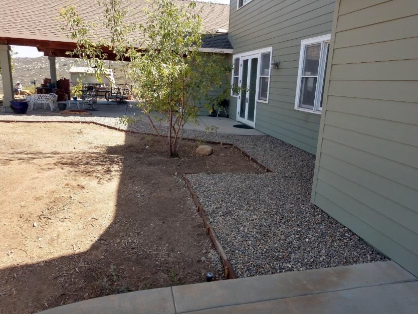
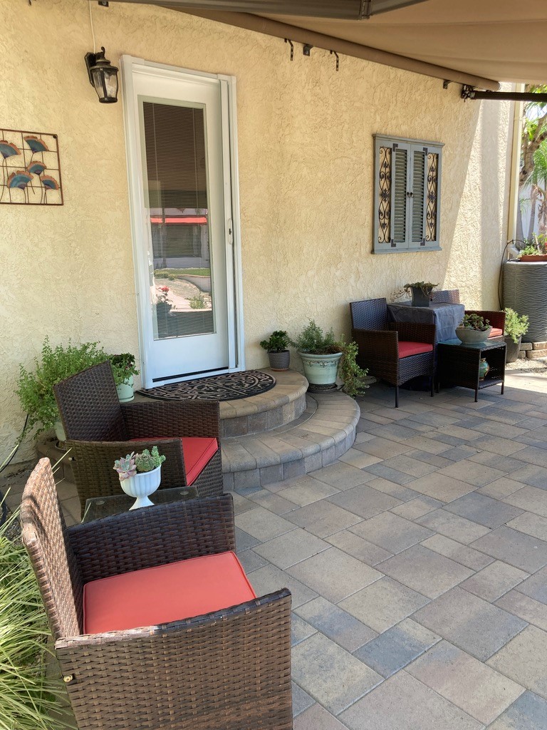
Figure 1: An example of Zone 0 (up to 5′ from the house) as part of the landscape installation.

Turning to individual homes, in tight communities like these, you typically don’t have large enough yards to implement beyond Zone 1. However, the zones closer to the house yield the greatest payoff. Even before the concept of Zone 0 was official, we had been creating 5-10’ aprons around the foundations of our customers’ homes. Whether composed of DG, gravel, concrete, or bare dirt, they were very effective at preventing flames reaching underneath the eaves. Zone 1, usually the next 30-50’, is the domain of hard-scape and permanently irrigated plantings. Northern coastal manzanita, Ceanothus, Clinopodium, Erigeron, Epilobium, etc. do very well for this.

Beyond the scope of this article, we need to start looking at community-based fire response. There will never be enough firefighters or engines to guarantee home protection in a conflagration like this. A number of countries are implementing a program of volunteer fire fighters local to the residential areas that are trained and equipped to put out spot fires, which is often how structure fires start. Those with pools should have gas-powered pumps and fire hoses, as the first things to go in large fires are electricity and water pressure, which was very evident in this case.

My last piece of advice would be GET RID OF THE PALMS!

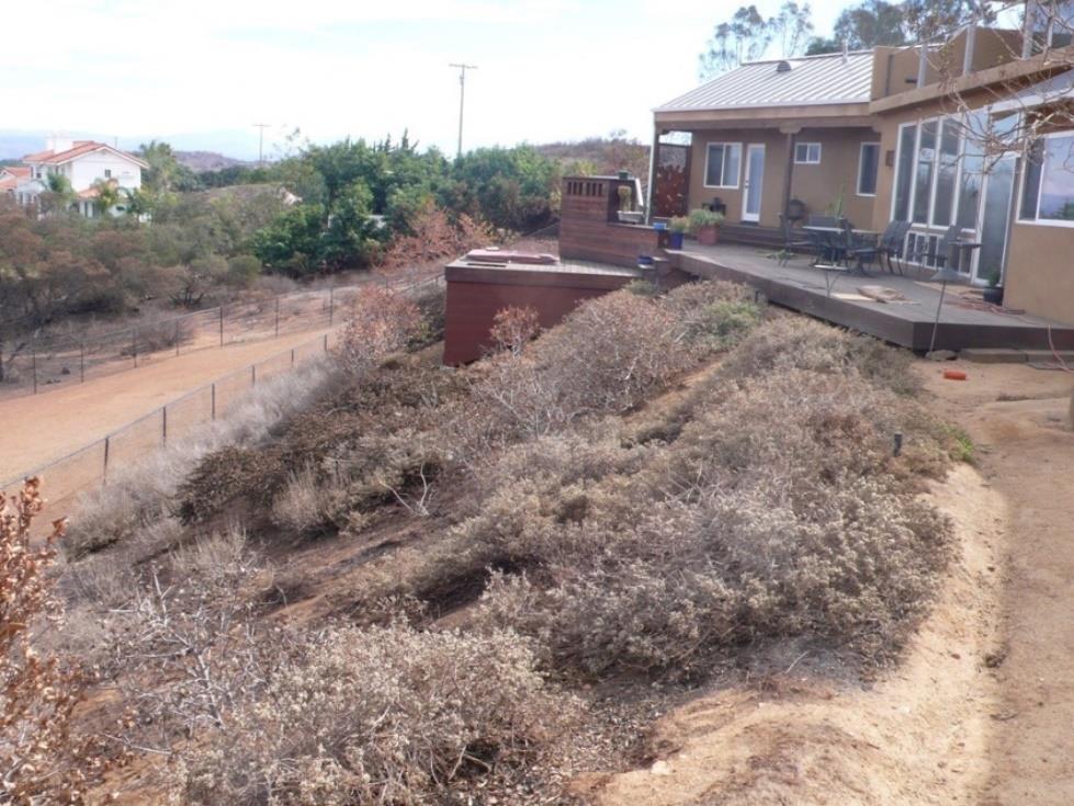
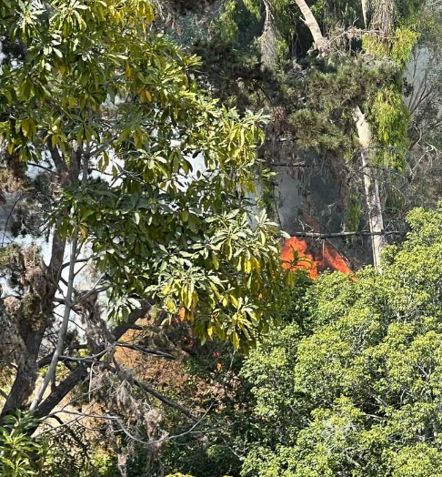
Figure 2: An example of a native landscape that, although singed, is perfectly alive. Its hydration level and ember catching ability helped prevent the ignition of the large wooden deck at the back of the house during the Witchcreek fire of 2007

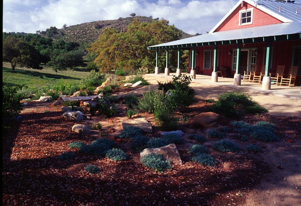
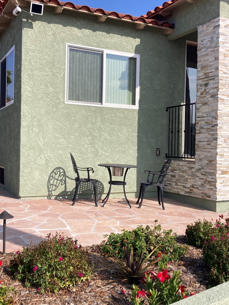
Figure 3: Decomposed granite apron between the house and landscape. This house has survived 3 wildland fires since this installation in 1998.

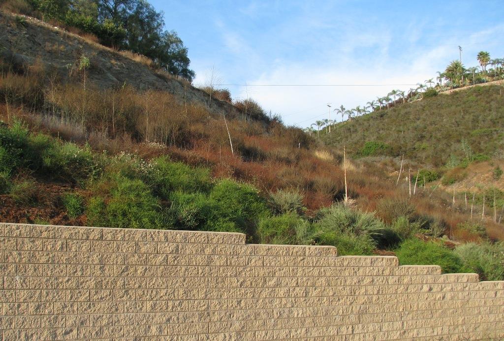
Figure 4: Light hydration of naturally occurring Coastal Sage Scrub contrasts with the unirrigated portion beyond. The plants are not overgrown nor unhealthy, just hydrated.

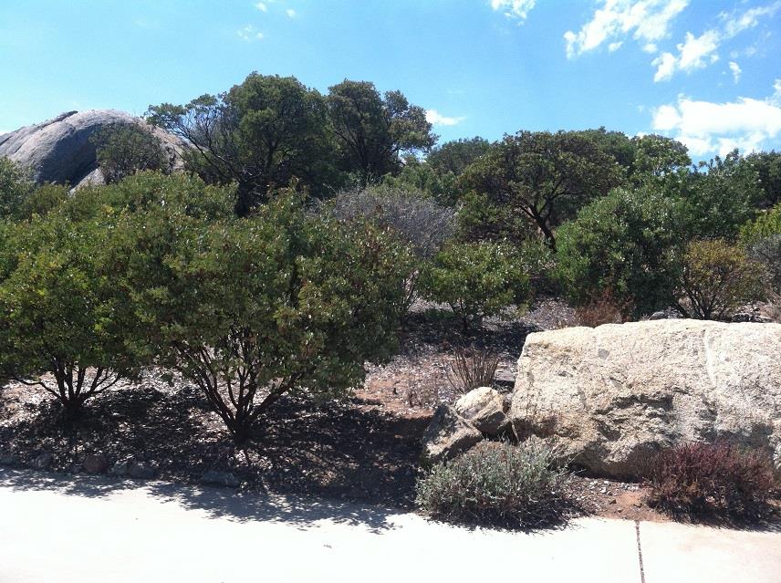
Figure 5: This is how existing chaparral should be thinned (no more than 50%). This is what should be done where natural vegetation comes up against the community greenbelt. You end up with a beautiful park-like setting, while also preserving the plant community and all the habitat that goes with it.

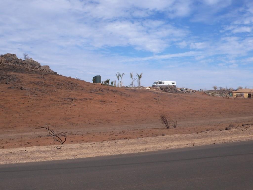
Figure 6: This is what hundreds of feet of clearing beautiful, pristine chaparral got this homeowner, unfortunately. The perfect bowling alley for embers. We see this repeatedly.

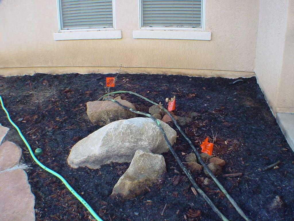
Figure 7: This is an example of how the consolidated shredded redwood bark actually behaves in fires. With overhead irrigation it mats down to less than an inch thick and adheres to the soil. In this case, you can clearly see the scorch marks at the base of the house – <2″. Also note the un-melted marker flags that were placed BEFORE the fire (except the one that is partially melted due to the burning hose!). Also note the drain grate next to the flagstone that is unaffected.

California’s Own Native Landscape Design, Inc.
25950 Los Arboles Ranch Rd
ESCONDIDO, CA 92026
(760)-746-6870
www.calown.com

Categories
Fire Safe News

Kensington residents concerned about fire risk posed by illegal encampments

On Tuesday, January 21, 2025 KPBS ran a story about the risks of wildfire due to illegal camping near Kensington. Amy Dyson, Judy Harrington and Mike Baldwin, all KFS board members, were interviewed. Watch the story.

Categories
Fire Safe News MetroView Fire-ey Questions

Where Do You Go for Wildfire Info?

By Judy Beust Harrington, Co-Chair, Kensington Fire Safe Kensington’s Fire Safe Council will share researched answers to your inquiries here. Send fire-related questions to info@kensingtonfiresafe.org.. Pictures appreciated!

Last month’s Montezuma Fire spurred over 85 questions from residents, both during the blaze, and later from the 260 folks at the SD Fire-Rescue “What Happened and What’s Next” follow-up presentation, November 21st at Hoover High School. 

This is the first installment of answers to questions we were unable to get to during the event.  We’ll be publishing them here as well as on Nextdoor and our website.

If you missed this detailed presentation check it out at kensingtonfiresafe.org.  You’ll learn exactly how flames entered and destroyed one home, instead of the dozen or more that firefighters initially thought would be lost in the blaze.  

Q:  What are the best sources for wildfire updates? 

A:  San Diego’s Office of Emergency Services website recommends downloading Genasys Protect for real time danger and evacuation notifications provided by authorized public officials. It divides a county into smaller zones, each with a unique identifier to help officials communicate about affected areas much more quickly than in the past. More information at protect.genasys.com.

Most people we talked to during the fire were using the WatchDuty mobile app, although it didn’t seem to have very frequent updates.  According to a Washington Post article last June, it’s a successful but low-budget service mostly run by volunteers, including retired firefighters, who pull info from law enforcement sites, news briefings, video feeds of fires, radio communications and other sources.

We should all register our cellphone # and email address with AlertSanDiego.  Emergency responders use it to send evacuation and incident information.  Their disaster feed also provides some basic data on current and past fires.

San Diego Fire-Rescue Department’s “X” feed also lists fires and provides background info. https://x.com/SDFD/status/1852497271625269360

You can sign up for SDG&E power shut off alerts at: https://www.sdge.com/notifications.  Even if you are not the bill payor, you can register on the app so you also get the alerts. Be sure to keep your contact info updated.

ALERTCalifornia (https://alertcalifornia.org/) utilizes AI for detecting smoke and other early fire indications via over 1,000 cameras placed in various forests. In the first two months of use, it correctly identified 77 fires before any 911 calls came in.However, it didn’t detect the Montezuma fire – likely because the closest camera appears to be at Cowles Mountain.

A wildfire-focused UC-Berkley engineering professor, who mostly uses Watch Duty for fire info, warned that apps can’t take the place of official communications from government agencies: “No information source is completely reliable. Mobile phone and internet service can fail during fires and cut people off from communications.(1)

So maybe keep those radios and TVs on too, plus have a portable charger ready for your cell phone, in case power is shut off.

Q: What does it really mean when a wildfire is “contained”? 

A: During the recent fire, many were confused by the low “% contained” reports even after the highly visible flames were gone and smoke was a mere fraction of what was previously witnessed.

Deputy Fire Chief/Fire Marshal Anthony Tosca explained to us that flame and smoke do not determine the degree of “containment” in a vegetation fire. Instead, the term refers to the extent to which fire crews have managed to create a barrier around the fire’s perimeter to stop it from spreading. This barrier or “fire line”, is created by removing vegetation and other flammable materials or using natural or constructed breaks in the landscape to act as a boundary. 

For example, when a fire is “50% contained” it means that half of the fire’s perimeter is surrounded by these controlled barriers. Full containment, at 100%, means the entire perimeter of the fire is encircled by a fire line, greatly reducing the risk of further spread.

Q: If you have time, should you hose down your yard and home before leaving? 

A: Again, Chief Tosca clarified for us: “Hosing down your yard and home before evacuating may seem like a good idea, but it’s not recommended for a few reasons:

1.   Water Won’t Last:  The water you spray on your home will quickly evaporate, especially in the heat and wind of a wildfire. Once it dries, it won’t provide any lasting protection, and your home would be just as vulnerable as if it hadn’t been watered at all.

2.   Every minute counts: Hosing down your yard and home can take valuable time and increase the risk of you being caught by the fire. Better to leave promptly and let firefighting teams manage structure protection.

3.   Water Pressure for Firefighting: In a wildfire situation, firefighting crews rely on a consistent water supply to combat the fire. Excessive water use by homeowners can reduce water pressure, which may impact firefighters’ ability to protect your neighborhood.”

Extra!  Extra!

Help save firefighters lives – when you see the flashing lights of a red fire truck that’s positioned diagonally across a highway lane, it’s to block traffic away from the ambulance and mangled car in front. At 65+ mph, cars zipping in front of that truck put firefighters and emergency personnel’s lives at risk! Please do not rush back into the lane as soon as you pass the fire truck.  Stay away until you are well past the accident!

(1) https://www.washingtonpost.com/technology/2024/06/21/wildfire-tracker-map-app/

Categories
Fire Safe News MetroView Fire-ey Questions

Been Hit Yet With Odd New Insurance Queries?

By Judy Beust Harrington, Co-Chair, Kensington Fire Safe (KFS)

Kensington’s Fire Safe Council will share researched answers to your inquiries here. Send fire-related questions to info@kensingtonfiresafe.org.  Pictures appreciated!

Q:  Are We a “Fire Risk Reduction Community”?

A:  A neighbor recently contacted us about this question on a homeowner insurance application: Is Kensington either a “Fire Risk Reduction Community” or a “Firewise Community?”

Sorry, nope – we’re not either one, but wish we were. 

Attaining a Firewise designation is a very challenging, long-term process requiring a lot of volunteer residential involvement. It’s likely more achievable for condo associations.  According to the Firewise website, some insurance companies do offer discounts to residents residing in Firewise USA sites. (https://www.nfpa.org/)

On the other hand, a “Fire Risk Reduction Community” designation or “FRRC” seems more do-able. It requires local community assessment of fire vulnerabilities and a comprehensive plan to reduce risks.  While San Diego County is on the list of FRRCs, the City of San Diego is not. We reached out to Fire Marshall Anthony Tosca about it, and he said the city plans to apply for this designation next time the opportunity becomes available. Perhaps this designation might mean a possible rate discount in the future for homeowners.

Meanwhile, if you want to see how your insurance costs compare to others, you could check out Bankrate’s website, although our insurance advisor, Scott Caraveo said they only list insurers who pay to be listed, and some aren’t doing business in California.  If you submit your contact info, you’re likely to be bombarded with phone calls and emails from brokers. https://www.bankrate.com/insurance/homeowners-insurance/homeowners-insurance-cost/

BTW, there’s also something called a Comprehensive Loss Underwriting Exchange” (CLUE) report on a homeowners insurance claims history.  Homeowners can request a copy under the federal Fair Credit Reporting Act, toll-free at 1-866-312-8076 or by visiting consumer.risk.lexisnexis.com.  Scott says insurance companies use reports like CLUE all the time, but CLUE reports don’t always include your specific claims history – it could include claims made at the property before you owned it or claims you made at a prior residence. In any case, insurance carriers already know about these events and are taking them into consideration each year.

Is My Home’s Fire Score Online?

Thank you, Sandra Johnson, for pointing out to us that some real estate sites are now including a fire risk score. I checked Realtor.com for a house for sale on Sussex, and here’s what it showed:

Realtor.com fire risk information for a Sussex Drive home for sale.

Glad to see it says “minimal” although, that seems odd since much of Kensington is designated a Very High Fire Risk Hazard Area. Both Scott and I wonder about the accuracy of these ratings. Realtor.com has a pretty good Q&A on their scoring: https://www.realtor.com/wildfire-risk/.

Other sites also providing fire ratings include:  

  • Wildfirerisk.org: Shows risks on a color-coded map when you search by town, county, or state. 
  • Riskfactor.com: Shows a fire score for any property in the continental USA. The fire factor scale ranges from 1 to 10, with 1 indicating no modeled exposure to wildfire and 10 indicating a greater than 36% chance of burning over 30 years. 
  • FirstStreet.org: Bases wildfire risk on a region’s vegetation, topography, and fire-related weather. 
  • ClimateCheck: Provides a free climate risk assessment for any address in the U.S. 
  • CoreLogic: Provides a wildfire risk score that evaluates available fuel, as well as the topography of the land.

While these may be good tools for selling a house, they’re unlikely to sway insurance companies on your property’s safety. More accurate may be the Fire Hazard Severity Zone (FHSZ) maps, although I find them a bit hard to work with since they don’t name major roads and highways.  They can be found at: https://osfm.fire.ca.gov/

We wish all those struggling to keep, find or afford their insurance luck – we’ve had our own challenges too!

Fire-safe Materials?

Last note – a reader of our Sept-Oct column on Zone Zero asked if there are any non-flammable cushions one could have on porch wrought iron furniture and still meet the future five-foot-from-the house zero flammability requirement.  Any thoughts on that, folks?

Categories
Community Presentations Fire Safe News

Montezuma Fire: The Miracle of Only One Home Lost. What Happened and What’s Next

Residents give firefighters a long standing ovation for their success in fighting the Montezuma Fire, at the recent community forum sponsored by Kensington Fire Safe and Alvarado Estates Fire Safe Council.

On October 31, 2024, San Diego witnessed its second-largest fire in history. The Montezuma Fire, which erupted on Montezuma Road just east of Fairmount Avenue, drew a massive emergency response. Within about 10 minutes, the first crews arrived on the scene. Over 350 personnel—including fixed-wing aircraft, helicopters, engine strike teams, hand crews, and specialty apparatus from CalFire, San Diego Police, and other agencies—worked tirelessly to contain the blaze.

Their efforts paid off. Despite early concerns that the fire would devastate multiple homes, only one house was damaged beyond repair.

(For more information on the Montezuma fire read Alvarado Estates Fire Safe Council Chair Karen Austin’s article.)

Judy Harrington, Kensington Fire Safe Co-Chair, speaks at the meeting. Karen Austin, Alvarado Estates Fire Safe Council Chair, stands to the left of her.

On November 21, nearly 300 residents gathered at Hoover High School for a program to learn more about the fire and how to prepare for future wildfires. The event, organized by Kensington Fire Safe and Alvarado Estates Fire Safe Council, featured a welcome by the new head of the San Diego Fire-Rescue Department, Chief Robert Logan, and presentations by Dan Eddy, Assistant Fire Chief of Emergency Operations, and Assistant Fire Marshall Alex Kane. This was followed by a Q&A session with officials including Council President Sean Elo-Rivera, Lieutenant Christian Sharp of the San Diego Police Department, and Parks and Recreation Opens Spaces Deputy Director Erika Ferreira and Senior Park Ranger Erika Weikel.

“I will tell you, from being a 25-year firefighter…when I pulled up on the scene, I expected us to lose 15 to 20 homes,” said Chief Dan Eddy during his review of the fire. He commended the new evacuation system, describing it as a significant improvement over previous processes, and praised both firefighters and police for their swift and effective evacuation efforts, noting they “did a phenomenal job of getting people at risk out.”

The program, planned just three weeks after the fire to address residents’ pressing questions and concerns, was co-sponsored by the San Diego Fire Foundation, Kensington-Talmadge Community Association, College Area Community Council, and the Fire Safe Councils of San Diego County.

The presentation was recorded on video and you can watch it in four sections:

Section 1 – Introductions, standing ovation for SDFR, welcome from SD Fire Chief, Robert Logan and special Congressional recognition for longtime Armed Services YMCA board member and volunteer Elaine Boland, who lost her home in the fire (13 minutes)
Section 2 – Fighting the Fire: Dan Eddy, SDFR Assistant Chief of Operations (16 minutes)
Section 3 – How that House Caught Fire and How to Protect Your Home: SDFR Assistant Fire Marshall Alex Kane (23 minutes)
Section 4 – Q & A (31 minutes)

We are extremely grateful to Kensington resident Charles Stebbins for recording the presentation for us.

You can view all the photos from the event on DropBox. Thanks to Kensington resident Gary Payne, husband of our own board member Zoraida Payne, for these great shots.

For more details, see the local news coverage from KPBS:
Fire Officials Answer Questions About Brush Management, Traffic Control After College Area Fire.

Categories
Fire Safe News MetroView Fire-ey Questions

Ready for Zone Zero Around your Home?

By Judy Beust Harrington, Co-Chair, Kensington Fire Safe (KFS)

Kensington’s Fire Safe Council will share researched answers to your inquiries here. Send fire-related questions to info@kensingtonfiresafe.org.  Pictures appreciated! 

Q:  Is AB 3074’s new radical Zone Zero requirement in effect?

A:  Assembly Bill 3074, passed in 2020, may be a BIG change for homeowners. 

Passed in 2020, this legislation requires a five foot “zone zero” around homes in areas with high fire risk. That zone is not to contain ANY flammable materials. This means no artificial turf, trellis, pergolas, shade covering, wood planters, attached combustible fences or gates, mulch, etc.…basically anything that can catch fire. But, don’t panic; the rules aren’t out – yet. 

The good news is, this requirement can certainly help keep our homes safer from spreading flames and flying embers, which have been seen in some recent canyon fires. We’ve been told that airborne, blazing Mexican fan palm fronds can travel the length of a football field!

The bad news is most of us like seeing shrubbery, flower boxes or other decorative plants right outside our windows. Seems like very few area residences are currently free from flammables that close to their house. But maybe we need to be open-minded. There actually are some attractive yards with almost a five-foot zero non-flammable area, as pictured.

Small patios like these next to the house might meet future “zone zero” requirements, although  in the event of a fire, you’d have to be home and have time to move any flammable items.

The question is, if it only applies to structures located in a “High” and “Very High” Fire Hazard Severity Zone (VHFHSZ), does that include my residence? Chances are, yes, because much of San Diego and particularly Kensington is in high or “VHFHSZs”. You can check your location at:  https://www.sandiego.gov/fire/services/brush/severityzones

When will this apply to me?

Before enforcement of the new zero zone can occur, the State Fire Marshal must approve the implementation. That’s projected to happen for new construction in 2025, and for existing structures one year later.

Zone Zero was one of several key topics covered at last month’s KFS presentation at Kensington Community Church, by Assistant Fire Marshall Daniel Hypes and Deputy Chief Marshal Anthony Tosca, from the SD Fire Department, as well as Parks and Recreation Deputy Director Erika Ferreira and Open Spaces Division Project Officer II, Laura Ball.

Marshall Hypes provided details about door-to-door defensible space inspection of canyon rim homes, management of vacant lots and, with Parks and Rec, brush management program of city properties.

Officer Ball covered Open Spaces Division efforts, including handling brush complaints, and more recently, the real estate defensible space inspections required to sell a home. They are now training more assessors so they can expand this service. They also have a  “Subdivision Review Program” to identify at-risk areas with at least 30 dwelling units in VHFHSZs with only one way in and out. Our community relations officer, Joshua Cummings, drove through the Alder Loop area after we mentioned our limited access.  You can learn a lot more by listening to the presentation at: https://shorturl.at/3VF7k 

Is My Home Ready for Fires?

Finally, remember there’s free home hardening assessments available. You have to register far in advance, but our neighbors Bill and Nancy Bamberger just had their house inspected after signing up on the County Fire Safe website–http://www.firesafesdcounty.org/hap, and were very pleased with the result.

Bill said, “The inspector spent an hour at our house, giving us specific advice on how to make our house more fire resistant. She recommended replacing our wooden gate with a metal one and told us where we could find a gate that would work. She acknowledged that some of her recommendations were costly but told us about cheaper alternatives. All-in-all, we got very useful advice!”

Tying all this back to the new Zone Zero – don’t be surprised if your insurance company tells you to make some changes. A good example is the beautiful but highly flammable and invasive — and now gone – white melaleuca trees on Marlborough and Ridgeway.  We’re hearing more cases where homeowners had to do some hardening to secure insurance.

We wish all those struggling to keep, find or afford their insurance luck – we’ve had our own challenges too!

Fall Dumpathon is Coming!!

Kensington Fire Safe is excited to announce our Fall Dumpathon, Thursday, 9/26 to Monday, 10/7.  During this time, dumpsters will be located throughout the Kensington neighborhood, allowing residents to dispose of extra greenery trimmed from their properties. This initiative helps make our community safer from wildfires!

This project is made possible by the San Diego Fire Foundation, support from Council President Elo-Rivera’s office, EDCO Disposal Company, and our dedicated neighborhood volunteers.

###

  1. https://www.cityofventura.ca.gov/FAQ.aspx?QID=713
  2. https://www.philomathfire.com/insurance-services-office-iso-information#:~:text=ISO%20is%20the%20principle%20provider,industry%20in%20the%20United%20States
Categories
Fire Safe News

Alder Canyon Fire on September 8, 2024

A fire broke out in the canyon on Alder Drive near Hart Drive on Sunday, September 8, 2024, around noon. Thankfully, no one was injured, and no structures were damaged.

With temperatures soaring to 103 degrees in Kensington that day, conditions were ripe for a fire. The response was swift, with four fire trucks and five police cars arriving at the scene. A fire helicopter circled overhead, though it did not make a water drop.

Firefighters quickly tapped into the hydrant at the corner of Argos and Hart Drive, pumping water into the canyon and extinguishing the blaze within hours. A woodpile, along with a patch of grass and shrubs down the canyon slope, were charred, but that seems to be the extent of the damage.

A few neighbors were evacuated as a precaution but were allowed to stay nearby to observe the situation.

Judy Harrington, co-chair of Kensington Fire Safe, spoke with one of the firefighters the following day. They suspect the fire was caused by an overheated electrical wire due to high demand with everyone having their air conditioning on. Same for another fire that started shortly thereafter near N Kensington. There were no indications of homeless encampments in the Alder canyon area.

A representative from Sean Elo-Rivera’s office reached out to Kensington Fire Safe the next day, offering assistance if needed.

We hope this close call inspires Kensington residents to clear flammable brush from their yards and canyon areas during the upcoming Dumpathon. With fires on the rise, reducing potential fuel is essential to keeping our neighborhood safe.

Categories
Fire Safe News MetroView Fire-ey Questions

How Does Our Fire Department Compare to Others?

By Judy Beust Harrington, Co-Chair, Kensington Fire Safe (KFS)

Kensington’s fire safe council will share researched answers to inquiries from community members here – if you send your fire-related questions to info@kensingtonfiresafe.org.  Pictures appreciated!

Q.  Is there a measurement showing how San Diego’s fire department stacks up to other fire departments?

A: This time the answer came before the question. Recently Kensington Fire Safe Council member, John Pringle, chatted with me while walking his dog.  John happened to mention that our San Diego Fire Department has an “ISO” rating. 

Here’s what we learned: the “Insurance Services Office,” is a subsidiary of Verisk Analytics, which provides statistical data for insurance companies. They assign an ISO “Public Protection Class (PPC)” from 1 to 10, based on an evaluation of a community’s ability to protect the public from fires.” (1) (2)

That evaluation involves an assigned value to the following  categories and weights:(3)

  • 50%: issues like staffing levels, training, firehouse proximity.
  • 40%: availability of water and fire hydrants.
  • 10%: emergency communication systems.

Extra points may be earned based on community outreach, like fire prevention and safety courses.  On the other hand, having areas that exceed five driving miles from the nearest fire station also affects scoring.

How do we rate?  Drum roll please… As of the last rating assessment in 2017, San Diego’s was a “2″ — with “1″ being the best. This is very impressive considering only 45 out of 854 California fire departments nationwide achieved a “1” – per the chart and article below.  Apparently ISO evaluations are typically done every 10 years, so we’re probably not yet due for another one. (4) (5)

Of course, the next obvious question is – does that rating help when it comes to our homeowner insurance costs and availability?

Does the rate matter?

Based on discussions with John and KFS insurance advisor, Scott Caraveo, the ISO rating may or may not be used by insurance companies in their complex process for determining community rates.

“Insurers don’t really provide discounts for lower PPC scores…safer areas just cost less.” Scott clarified.  “Most California carriers work off a combination of both FireLine, parcel-based modeling and PPC, which is community-based risk modeling. Overall, community-based modeling is safer for companies because they can apply a broader rate to a general area, as opposed to setting different rates for each individual household in that same area.

“Consumers might appreciate parcel modeling quite a bit, but that would also be a LOT more tedious for companies (and agents/brokers!), and consumers would likely see a lot more variance on their insurance rates from house-to-house as a result.”

The FireLine data Scott mentioned is also provided by the risk assessment company, Verisk, in collaboration with the National Fire Protection Association.  Its FireLine analysis includes property-specific mitigation efforts like defensible space and other home hardening measures, as well as fuel, slope, wind patterns and other factors.  

For a past column, KFS asked Verisk about the extent to which density is considered, and a spokesperson confirmed that it is a factor although how much it influences their fire risk scoring is unclear.  We are talking to Verisk about a possible presentation to our community —  tell us if that’s something you might be interested it. (info@kensingtonfiresafe.org). 

Meanwhile, there’s comfort in knowing our fire department is among the few in the top two ISO performance classifications. One website I visited for another California area with a high ISO recommended homeowners remind their insurance company of that good rating. 

Seems like it couldn’t hurt — unlike the rate increases or cancellations unfortunately neighbors are seeing these days.

###

(1) https://www.philomathfire.com/insurance-services-office-iso-information#:~:text=ISO%20is%20the%20principle%20provider,industry%20in%20the%20United%20States

(2) https://einhorninsurance.com/insurance-advice/fire/high-brush-home-insurance-public-protection-class/#:~:text=What%20does%20Protection%20Class%20or,the%20worst)%20to%20a%20home.

(3) https://mcesd8.org/class1iso/#:~:text=More%20than%2050%2C000%20fire%20departments,earned%20a%20Class%201%20rating.

(4) https://www.newportbeachca.gov/government/departments/fire/iso-class-i-rating

(5) https://www.princeton-il.com/departments/fire___ems/iso_public_protection_class_rating.php#:~:text=The%20Public%20Protection%20Classification%20(PPC,to%20the%20related%20evaluation%20criteria

Categories
Fire Safe News

Kensington neighbors take wildfire prevention measures

On October 9, 2023, NBC’s local news aired this story about how Kensington is preparing for a possible wildfire. The story features our own Kensington Fire Safe co-chair Judy Harrington. Watch the story here.

Categories
Community Presentations

Community Presentation – How will the City Manage our Canyon Brush?

You can watch the full presentation here and view the overheads here.

Guest presenters and other staff included Assistant Fire Marshall Daniel Hypes, Deputy Chief Fire Marshall Anthony Tosca, Parks and Rec Deputy Director Erika Ferreira and Project Officer II for the Open Space Division Laura Ball, Code Compliance staff Raquel Elias and Steven Macias and our Community Liaison Police Officer Joshua Cumming.

Key topics included:

  • Efforts to identify very high fire hazard areas without a secondary egress route and follow-up actions
  • Updated recommendations on home hardening against flying embers
  • New defensible space zone recommendations
  • Open Space surveys and brush thinning strategies
  • Right of Entry permit process

In addition to numerous questions, many stayed afterwards to talk to our presenters about their specific concerns. Follow-up action on nearby encampments took place over the next few days, thanks to Officer Cummings and some great Talmadge neighbors.


Much appreciation goes to all who helped:

  • Flyer design/ copying/distributing by Amy Dyson, Ryan Hunter, Zoraida Payne, and Vicki Pinkus.
  • Room setup, etc: Amy, Brian and Zion Dyson, Ryan Hunter and JB Finnell, Bill Harrington, Karen Austin and Eric Sands from Alvarado Estate FSC, and many attendees too.
  • Some very valuable help from Kensington-Talmadge Library, Pappaleco’s and videographer Charlie Stebbins.
  • Co- sponsor support from:
    • Alvarado Estates Fire Safe Council
    • Kensingtion-Talmadge Community Association

Kensington Fire Safe appreciates all this support and the neighbors who attended so they could learn how to make us all safer from wildfire.